
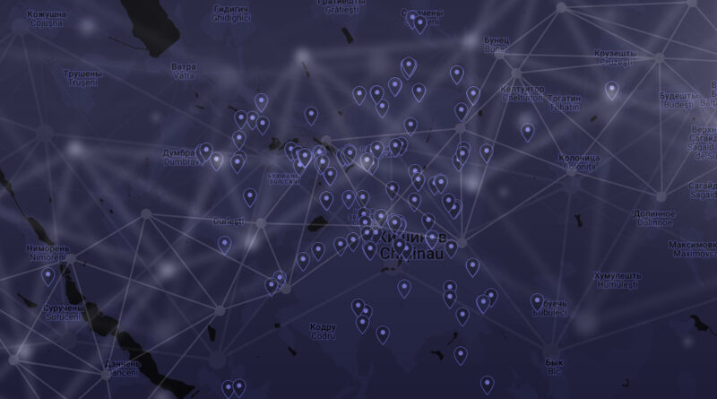
Geographic Distribution & Corridor Coverage July 2026
REPUBLIC OF MOLDOVA
Supplement to the Comparative Market Analysis · July 2026
All figures reflect the 295 stations in scope on July 15, 2026. This analysis covers Moldovan right-bank territory only. The left bank (Transnistria) operates under a separate legal regime, payment infrastructure, and currency.
Coverage at a Glance
| Metric | Value | Context |
|---|---|---|
| Settlements with charging | 31 | Across right-bank Moldova |
| Stations in Chișinău municipality | 168 | 57% of the national network |
| Right-bank population outside Chișinău | ~75% | Served by 43% of stations |
| Longest highway gap | 88 km | M3 south: Ceadîr-Lunga → Giurgiulești |
| Border crossings with no stations | 3 of 5 | Otaci, Palanca, Giurgiulești |
| Raion centers with 0 stations | 8 | Incl. Vulcănești, Dondușeni, Ocnița, Basarabeasca |
Distribution by Settlement
| Settlement / Area | Stations | Share | Note |
|---|---|---|---|
| Chișinău municipality | 168 | 56.9% | Incl. Ciocana, Codru, Cricova, Bacioi, Trușeni, Sîngera, Ciorescu |
| Bălți | 16 | 5.4% | Northern hub |
| Cahul | 9 | 3.1% | Southern hub |
| Orhei | 8 | 2.7% | |
| Ungheni | 5 | 1.7% | |
| Anenii Noi | 5 | 1.7% | |
| Florești | 5 | 1.7% | |
| Comrat | 4 | 1.4% | Gagauzia |
| Edineț | 4 | 1.4% | |
| Ialoveni | 3 | 1.0% | Chișinău satellite |
| Sculeni (RO border) | 3 | 1.0% | |
| Călărași | 3 | 1.0% | |
| Cimișlia | 3 | 1.0% | |
| Drochia | 3 | 1.0% | |
| Căușeni | 3 | 1.0% | |
| Soroca | 3 | 1.0% | |
| Bulboaca | 2 | 0.7% | |
| Cornești (M1) | 2 | 0.7% | Highway stop |
| Fălești | 2 | 0.7% | |
| Hîncești | 2 | 0.7% | |
| Nisporeni | 2 | 0.7% | |
| Sîngerei | 2 | 0.7% | |
| Telenești | 2 | 0.7% | |
| Briceni, Cantemir, Ceadîr-Lunga, Criuleni, Leova, Rezina, Strășeni, Ștefan Vodă | 8 | 2.7% | 1 station each |
| Rural / highway / unmatched | 28 | 9.5% | Small villages, service stops |
| TOTAL | 295 | 100% |
Settlements classified by nearest match to a curated list of Moldovan localities within a 3.0–8.0 km radius depending on locality size. 28 points did not match any listed settlement — most are on inter-city highways or in small villages.
Market Concentration
| Coverage tier | Stations | % of network | Reference |
|---|---|---|---|
| Chișinău alone | 168 | 57.0% | Population share ~25% |
| Chișinău + top 4 cities (Bălți, Cahul, Orhei, Ungheni) | 206 | 69.8% | Population share ~35% |
| Top 10 settlements | 227 | 76.9% | |
| All raion centers + major cities | 235 | 79.7% | |
| Non-urban / highway / small settlements | 60 | 20.3% | Incl. 28 unmatched |
Highway Corridor Coverage & Gap Analysis
| Corridor | Route | Length | Largest gap | Assessment |
|---|---|---|---|---|
| M14 (north) | Chișinău – Orhei – Bălți – Edineț | 220 km | 40 km | Densest inter-city corridor. Short unserved stretch near the UA border approach. |
| M2 (northeast) | Chișinău – Orhei – Florești – Soroca | 160 km | 49 km | Northeast route. Rezina has only 1 station. |
| R1 (west) | Chișinău – Călărași – Ungheni – Sculeni | 125 km | 43 km | Route to RO border via Sculeni. Middle stretch thin. |
| M1 (southwest) | Chișinău – Ialoveni – Hîncești – Leușeni | 68 km | 34 km | Short, well-covered corridor to RO border. |
| R34/M1 south | Hîncești – Leova – Cantemir – Cahul | 115 km | 48 km | Southern route. Leova and Cantemir have 1 station each. Reaching Cahul from Chișinău requires the M3 detour. |
| M3 (south) | Chișinău – Cimișlia – Comrat – Ceadîr-Lunga – Giurgiulești | 205 km | 88 km | Critical. Main N–S corridor to Danube port and RO/UA border. Last 90 km before Giurgiulești completely uncovered. Vulcănești and Giurgiulești have 0 stations. |
| R2 (southeast) | Chișinău – Anenii Noi – Căușeni – Ștefan Vodă – Palanca | 155 km | 50 km | Only route to Odessa (UA). Last 50 km before border uncovered. |
“Gap” = longest stretch along the corridor with no station within 5 km of the route. Corridors through Transnistria (M4 to Rîbnița, M21 to Dubăsari) are outside the addressable market and excluded.
Key Findings
Extreme concentration on the capital
57% of all stations sit inside Chișinău municipality, which has ~25% of the right-bank population. The top 5 cities (Chișinău + Bălți + Cahul + Orhei + Ungheni) account for 70% of the network. This is a typical pattern for an early-stage EV market — but it also means operators are competing for the same city customers while leaving most of the country without coverage.
The southern axis is the biggest infrastructure gap
M3 (Chișinău – Comrat – Giurgiulești) is the main north-south transit corridor leading to the Danube port and the Romania/Ukraine borders. The last 88 km — from Ceadîr-Lunga to Giurgiulești — have zero stations. Vulcănești (raion center) and Giurgiulești (port and border crossing) are both unserved. On the parallel R34 route, Hîncești → Leova is a 48 km gap with only 1 station each in Leova and Cantemir before reaching Cahul. Southern Moldova is effectively unreachable by EV without careful planning.
Border approaches are the weakest link
Three of five main border crossings — Otaci (UA), Palanca (UA), Giurgiulești (RO/UA/port) — have no charging stations in the last 40–90 km before the border. Only Sculeni (RO) and Leușeni (RO) have stations nearby. For cross-border EV travel with Romania and Ukraine, this is a basic barrier.
Transnistria is a separate market, not a coverage gap
Charging infrastructure likely exists in Tiraspol, Bender, and Rîbnița, but Moldovan operators cannot serve it: different currency, different banking system, no interbank clearance for card payments across the Nistru. This territory is excluded from all coverage metrics.
Eight raion centers still have zero stations
Basarabeasca, Dondușeni, Glodeni, Ocnița, Rîșcani, Șoldănești, Taraclia, and Vulcănești. These are the natural next locations for any operator expanding beyond the current top-10 pattern — all on the right bank, all addressable.
The northern corridor is the only success story
M14 (Chișinău → Orhei → Bălți → Edineț) is the only corridor with adequate spacing throughout. Every raion center on this route has at least one station. This is where inter-city EV travel actually works today.
57% of stations serve 25% of the population. Three of five border crossings have no charging. The main southern highway has an 88 km gap with zero coverage. The network is built for Chișinău, not for Moldova.
Methodology
Each station’s WGS-84 coordinates were matched to the nearest entry in a curated list of right-bank Moldovan settlements (all 32 raion centers, Chișinău suburbs, border crossings, and notable highway towns) using haversine distance with per-locality radii of 3.0–8.0 km. Corridor coverage was computed by projecting each station onto ordered corridor waypoints and measuring the largest along-corridor gap where no station is within 5 km of the route. Corridor lengths are approximate road distances. Population comparisons use pre-2024 National Bureau of Statistics estimates. Chișinău municipal boundary is approximated by grouping the city center and satellite localities (Ciocana, Codru, Cricova, Bacioi, Trușeni, Sîngera, Ciorescu). Transnistrian territory is excluded from all coverage metrics.
Source: open data collected from operator applications, July 15, 2026.
This is a supplement to the main report: Moldova EV Market: Infrastructure Report — July 2026